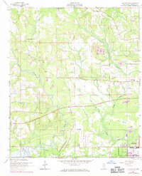
1956 Map of Gulfport NW
USGS Topo · Published 1971About this map
The Wolf River and its winding tributaries dominate this Harrison County landscape, illustrating the transition from rural timberlands and small farms toward the coastal expansion of Gulfport. Significant land tracts like the Alexander Dimitry Claim and the U S Naval Reservation define the southern portion of the map, while inland life is marked by small community centers like New Hope and Jones Mill.
Find a feature on this map
22 named features on this map. Tap any name to fly to it.
Don’t see what you’re looking for? This feature index may not catch every label — zoom into the map to look around manually.
Map Details
Editions of this 1956 Gulfport NW Map
5 editions found
Other maps of this area

1953 · Mobile
USGS Topo · 1:250,000

1954 · McHenry
USGS Topo · 1:62,500

1954 · Gulfport North
USGS Topo · 1:24,000

1954 · Gulfport South
USGS Topo · 1:24,000

1955 · Savannah
USGS Topo · 1:62,500

1955 · Pass Christian
USGS Topo · 1:24,000

1956 · Bay St. Louis
USGS Topo · 1:24,000

1956 · Vidalia
USGS Topo · 1:24,000

1956 · Gulfport NW
USGS Topo · 1:24,000

1957 · Mobile
USGS Topo · 1:250,000