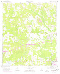
1956 Map of Gulfport NW
USGS Topo · Published 1978About this map
The Wolf River and its complex network of tributaries, including Bayou Bernard and Turkey Creek, anchor this coastal Mississippi landscape north of the sound. The map reveals a transition from the agricultural and rural character of the County Farm and Jones Mill toward the expanding infrastructure of the mid-20th century. Notable cultural and religious sites like Our Lady of Mercy Ch and Michael Memorial Ch are documented alongside earlier historical footprints such as the Alexander Dimitry Claim. The southern portion of the sheet shows the development of the U S Naval Reservation, while numerous pits scattered throughout the terrain suggest active resource extraction during this period of growth. This survey captures a mix of longstanding family and community markers, including Allen Cem and the Gulf Haven Ch Cem, set within a landscape being reshaped by new canal systems and highway routes.
Find a feature on this map
24 named features on this map. Tap any name to fly to it.
Don’t see what you’re looking for? This feature index may not catch every label — zoom into the map to look around manually.
Map Details
Editions of this 1956 Gulfport NW Map
5 editions found
Other maps of this area

1953 · Mobile
USGS Topo · 1:250,000

1954 · McHenry
USGS Topo · 1:62,500

1954 · Gulfport North
USGS Topo · 1:24,000

1954 · Gulfport South
USGS Topo · 1:24,000

1955 · Savannah
USGS Topo · 1:62,500

1955 · Pass Christian
USGS Topo · 1:24,000

1956 · Bay St. Louis
USGS Topo · 1:24,000

1956 · Vidalia
USGS Topo · 1:24,000

1956 · Gulfport NW
USGS Topo · 1:24,000

1957 · Mobile
USGS Topo · 1:250,000