
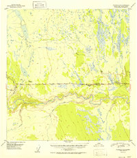
1952 Map of Gulkana A-4
USGS Topo · Published 1952About this map
Glennallen stands as a focal point of development along the Glenn Highway in the early 1950s, representing a critical junction in the Alaskan interior. This era shows a landscape transitioning toward increased accessibility, evidenced by the cluster of roadside establishments such as Glennallen Lodge, Georges Lodge, and Norms Lodge. These small outposts provided essential services to travelers navigating the route between Anchorage and the interior. To the south, the massive Tazlina River carves a deep valley, fed by tributaries like Nickel Creek and Durham Creek. The map documents the early infrastructure of the Alaska-Third Judicial Division, where the high-altitude terrain near VABM Shepard Spring contrasts with the marshy lowlands surrounding Moose Creek.
Find a feature on this map
15 named features on this map. Tap any name to fly to it.
Don’t see what you’re looking for? This feature index may not catch every label — zoom into the map to look around manually.
Map Details
Editions of this 1952 Gulkana A-4 Map
2 editions found
Other maps of this area

1948 · Valdez D-5
USGS Topo · 1:63,360

1949 · Gulkana A-3
USGS Topo · 1:63,360

1949 · Gulkana A-5
USGS Topo · 1:63,360

1949 · Valdez D-4
USGS Topo · 1:63,360

1949 · Valdez D-6
USGS Topo · 1:63,360

1950 · Gulkana B-3
USGS Topo · 1:63,360

1951 · Valdez D-5
USGS Topo · 1:63,360

1951 · Gulkana
USGS Topo · 1:250,000

1951 · Valdez D-6
USGS Topo · 1:63,360

1951 · Gulkana B-5
USGS Topo · 1:63,360