
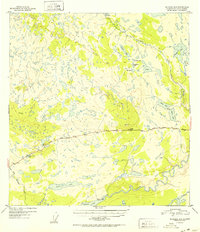
1952 Map of Gulkana A-5
USGS Topo · Published 1952About this map
Glenn Highway provides the primary corridor through this landscape of the Copper River basin, captured here just after the mid-century. Along this critical route, roadside landmarks like Atlasta House and the Tazlina Glacier Lodge served as essential waypoints for travelers in the Alaskan interior. The map reveals a transition between the glacial waters of Tazlina Lake and the complex network of smaller upland lakes to the north, including Sucker Lake, Frenchman Lake, and Moose Lake. To the south, the Tazlina River meanders toward its confluence, bordered by sites of local historical importance such as an Indian Cem near the riverbank. This survey documents the early infrastructure and the indigenous and commercial presence at a time when the region was defined by isolated lodges, small cabins, and the emerging highway system.
Find a feature on this map
22 named features on this map. Tap any name to fly to it.
Don’t see what you’re looking for? This feature index may not catch every label — zoom into the map to look around manually.
Map Details
Editions of this 1952 Gulkana A-5 Map
2 editions found
Other maps of this area

1949 · Gulkana A-5
USGS Topo · 1:63,360

1949 · Gulkana A-6
USGS Topo · 1:63,360

1949 · Valdez D-6
USGS Topo · 1:63,360

1949 · Valdez D-7
USGS Topo · 1:63,360

1950 · Gulkana B-6
USGS Topo · 1:63,360

1951 · Gulkana
USGS Topo · 1:250,000

1951 · Valdez D-6
USGS Topo · 1:63,360

1951 · Valdez D-7
USGS Topo · 1:63,360

1951 · Gulkana B-5
USGS Topo · 1:63,360

1951 · Gulkana A-4
USGS Topo · 1:63,360