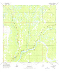
1950 Map of Gulkana B-3
USGS Topo · Published 1978About this map
Gakona sits at the vital confluence where the Gakona River meets the silty glacial waters of the Copper River. This 1950 survey, updated with 1970s revisions, documents the interior of Alaska during a period of massive infrastructure growth. The intersection at Gakona Junction marks the meeting of two historic Alaskan arteries: the Richardson Highway and the Glenn Highway. These roads provided the primary overland access to the Copper River Basin before the modern era. The landscape is defined by the braided channels of the Gulkana River and the Sanford River, carving through a terrain marked by numerous small lakes and swamps. Of particular interest is the inclusion of The Trans-Alaska Pipeline, shown tracing the highway corridor, representing the significant industrial layer added to this remote region in the late 20th century.
Find a feature on this map
19 named features on this map. Tap any name to fly to it.
Don’t see what you’re looking for? This feature index may not catch every label — zoom into the map to look around manually.
Map Details
Editions of this 1950 Gulkana B-3 Map
3 editions found
Other maps of this area

1949 · Gulkana A-3
USGS Topo · 1:63,360

1949 · Gulkana C-2
USGS Topo · 1:63,360

1949 · Gulkana B-2
USGS Topo · 1:63,360

1950 · Gulkana B-3
USGS Topo · 1:63,360

1950 · Gulkana C-3
USGS Topo · 1:63,360

1950 · Gulkana C-4
USGS Topo · 1:63,360

1951 · Gulkana
USGS Topo · 1:250,000

1951 · Gulkana A-4
USGS Topo · 1:63,360

1951 · Gulkana B-4
USGS Topo · 1:63,360

1952 · Gulkana A-3
USGS Topo · 1:63,360