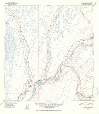
1952 Map of Gulkana B-3
USGS Topo · Published 1952About this map
The confluence of the Copper River and Gakona River anchors this interior Alaska landscape, showing the region as it transitioned into the mid-twentieth century. Settlement patterns are concentrated at the intersection of vital transport routes, with Gulkana and Gakona serving as primary hubs where the Richardson Highway and Glenn Highway meet. The presence of an Airstrip near Gakona and another south of Gulkana highlights the reliance on bush aviation alongside the road network for regional connectivity.
Find a feature on this map
19 named features on this map. Tap any name to fly to it.
Don’t see what you’re looking for? This feature index may not catch every label — zoom into the map to look around manually.
Map Details
Editions of this 1952 Gulkana B-3 Map
2 editions found

Other maps of this area

1949 · Gulkana A-3
USGS Topo · 1:63,360

1949 · Gulkana C-2
USGS Topo · 1:63,360

1949 · Gulkana B-2
USGS Topo · 1:63,360

1950 · Gulkana B-3
USGS Topo · 1:63,360

1950 · Gulkana C-3
USGS Topo · 1:63,360

1950 · Gulkana C-4
USGS Topo · 1:63,360

1951 · Gulkana
USGS Topo · 1:250,000

1951 · Gulkana A-4
USGS Topo · 1:63,360

1951 · Gulkana B-4
USGS Topo · 1:63,360

1952 · Gulkana A-3
USGS Topo · 1:63,360