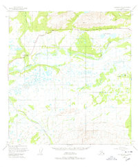
1949 Map of Gulkana C-1
USGS Topo · Published 1978About this map
Copper River and its vast network of tributaries dominate this 1949 landscape, where the braided river channels and surrounding low-relief wetlands were first mapped using aerial photography. The Glenn Highway provides the primary overland corridor, cutting across the northern reaches near the Indian River settlement. This era of mapping captured the region before significant modern development, showing the proximity of the highway to natural landmarks like Grizzly Lake and the Cobb Lakes. The drainage patterns of Flat Creek, Silver Creek, and Boulder Creek illustrate the complex water systems feeding into the Copper River basin, which has long served as a vital geographic landmark in Alaska's interior. Researchers will find the land lines represent unsurveyed locations predetermined by the Bureau of Land Management, reflecting the frontier state of the territory at the time of the survey.
Find a feature on this map
11 named features on this map. Tap any name to fly to it.
Don’t see what you’re looking for? This feature index may not catch every label — zoom into the map to look around manually.
Map Details
Editions of this 1949 Gulkana C-1 Map
3 editions found
Other maps of this area

1948 · Nabesna C-6
USGS Topo · 1:63,360

1949 · Gulkana C-2
USGS Topo · 1:63,360

1949 · Nabesna D-6
USGS Topo · 1:63,360

1949 · Gulkana B-2
USGS Topo · 1:63,360

1949 · Gulkana C-1
USGS Topo · 1:63,360

1950 · Nabesna
USGS Topo · 1:250,000

1951 · Gulkana
USGS Topo · 1:250,000

1951 · Nabesna
USGS Topo · 1:250,000

1952 · Nabesna C-6
USGS Topo · 1:63,360

1952 · Gulkana B-2
USGS Topo · 1:63,360