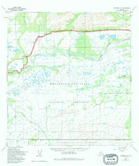
1949 Map of Gulkana C-1
USGS Topo · Published 1995About this map
The Copper River dominates this mid-century Alaskan interior landscape, carving a wide, braided path through the terrain as it appeared during the initial post-war surveying period. The Glenn Highway traces a narrow line of human development across the northern portion of the map, providing a vital transport corridor past Grizzly Lake and the Cobb Lakes. To the south, the vast protected reaches of the Wrangell-Saint Elias National Preserve and Wrangell-Saint Elias Wilderness are established, reflecting the region's transition into a preserved natural landscape. Watercourses like Boulder Creek and Ahtell Creek feed the larger river system, illustrating the drainage patterns of this subarctic environment before significant modern alteration.
Find a feature on this map
14 named features on this map. Tap any name to fly to it.
Don’t see what you’re looking for? This feature index may not catch every label — zoom into the map to look around manually.
Map Details
Editions of this 1949 Gulkana C-1 Map
3 editions found
Other maps of this area

1948 · Nabesna C-6
USGS Topo · 1:63,360

1949 · Gulkana C-2
USGS Topo · 1:63,360

1949 · Nabesna D-6
USGS Topo · 1:63,360

1949 · Gulkana B-2
USGS Topo · 1:63,360

1949 · Gulkana C-1
USGS Topo · 1:63,360

1950 · Nabesna
USGS Topo · 1:250,000

1951 · Gulkana
USGS Topo · 1:250,000

1951 · Nabesna
USGS Topo · 1:250,000

1952 · Nabesna C-6
USGS Topo · 1:63,360

1952 · Gulkana B-2
USGS Topo · 1:63,360