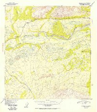
1952 Map of Gulkana C-1
USGS Topo · Published 1952About this map
The Copper River snakes through this high-latitude terrain, flanked by a complex network of glacial meltwater and drainage systems. Surveyed from aerial photographs taken in 1949, the map reveals a sparsely populated landscape where the Indian River settlement serves as a primary point of human presence. This interior region is defined by the corridor of the Glenn Highway, which provides the vital overland connection through the valley. The presence of numerous lakes and marshes, such as Cobb Lakes, indicates the permafrost-influenced hydrology of the area. High points like VABM Cobb 4353 and VABM 2305 Blue RM 1 establish the vertical relief of the surrounding mountains, while water bodies like Indian Creek, Ahtell Creek, and Boulder Creek carve through the foothills to reach the main river valley.
Find a feature on this map
12 named features on this map. Tap any name to fly to it.
Don’t see what you’re looking for? This feature index may not catch every label — zoom into the map to look around manually.
Map Details
Editions of this 1952 Gulkana C-1 Map
2 editions found

Other maps of this area

1948 · Nabesna C-6
USGS Topo · 1:63,360

1949 · Gulkana C-2
USGS Topo · 1:63,360

1949 · Nabesna D-6
USGS Topo · 1:63,360

1949 · Gulkana B-2
USGS Topo · 1:63,360

1949 · Gulkana C-1
USGS Topo · 1:63,360

1950 · Nabesna
USGS Topo · 1:250,000

1951 · Gulkana
USGS Topo · 1:250,000

1951 · Nabesna
USGS Topo · 1:250,000

1952 · Nabesna C-6
USGS Topo · 1:63,360

1952 · Gulkana B-2
USGS Topo · 1:63,360