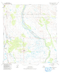
1949 Map of Gulkana D-3
USGS Topo · Published 1991About this map
The Gakona River dominates the central landscape of this interior Alaskan territory, carving a wide, braided path as it flows south toward the Copper River. Near the southwestern edge of the quadrangle, Meier Lodge sits along the shores of Meiers Lake, serving as a localized point of settlement along the historic Richardson Highway. This corridor is a hub of transportation and infrastructure, also featuring the Trans-Alaska Pipeline and several Radio Towers.
Find a feature on this map
16 named features on this map. Tap any name to fly to it.
Don’t see what you’re looking for? This feature index may not catch every label — zoom into the map to look around manually.
Map Details
Editions of this 1949 Gulkana D-3 Map
3 editions found
Other maps of this area

1949 · Mount Hayes A-4
USGS Topo · 1:63,360

1949 · Gulkana C-2
USGS Topo · 1:63,360

1949 · Gulkana D-3
USGS Topo · 1:63,360

1950 · Mount Hayes
USGS Topo · 1:250,000

1950 · Gulkana D-4
USGS Topo · 1:63,360

1950 · Mount Hayes A-3
USGS Topo · 1:63,360

1950 · Gulkana C-3
USGS Topo · 1:63,360

1950 · Gulkana C-4
USGS Topo · 1:63,360

1951 · Gulkana
USGS Topo · 1:250,000

1951 · Mount Hayes
USGS Topo · 1:250,000