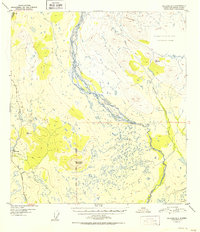
1952 Map of Gulkana D-3
USGS Topo · Published 1952About this map
Richardson Highway anchors the western edge of this subarctic landscape, following a corridor that served as a vital interior link during the mid-twentieth century. Near Mile 170, the Meier Lodge stands as a focal point for travelers and local residents alike. This settlement and its nearby survey marker, VABM 3353 Meiers, represent the sparse human footprint in an area dominated by glacial river systems. The braided channels of the Gakona River dominate the central valley, eventually meeting the Copper River to the south. East of the highway, a Tractor Trail provides access toward the base of Round Top Mountain, crossing several drainages including Otter Creek and Spring Creek. The terrain transitions from these water-rich lowlands to significant elevations, including the survey point at VABM 3678 Mark near Excelsior Creek.
Find a feature on this map
16 named features on this map. Tap any name to fly to it.
Don’t see what you’re looking for? This feature index may not catch every label — zoom into the map to look around manually.
Map Details
Editions of this 1952 Gulkana D-3 Map
2 editions found

Other maps of this area

1949 · Mount Hayes A-4
USGS Topo · 1:63,360

1949 · Gulkana C-2
USGS Topo · 1:63,360

1949 · Gulkana D-3
USGS Topo · 1:63,360

1950 · Mount Hayes
USGS Topo · 1:250,000

1950 · Gulkana D-4
USGS Topo · 1:63,360

1950 · Mount Hayes A-3
USGS Topo · 1:63,360

1950 · Gulkana C-3
USGS Topo · 1:63,360

1950 · Gulkana C-4
USGS Topo · 1:63,360

1951 · Gulkana
USGS Topo · 1:250,000

1951 · Mount Hayes
USGS Topo · 1:250,000