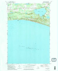
1972 Map of Gulliver
USGS Topo · Published 1975About this map
The coastal village of Gulliver serves as the focal point of this survey, situated where the Soo Line railroad skirts the northern edge of Gulliver Lake. The landscape is a complex network of inland waters and marshy depressions, including Little Muddy Lake, Anderson Lake, and Cookson Lake, all positioned behind the high coastal ridge of Nelson. This topography reflects the post-glacial environment of the Upper Peninsula, where drainage is slow and often collects in shallow basins like Palmer Lake and Minnow Lake before reaching Lake Michigan via the Gulliver Outlet.
Find a feature on this map
26 named features on this map. Tap any name to fly to it.
Don’t see what you’re looking for? This feature index may not catch every label — zoom into the map to look around manually.
Map Details
Editions of this 1972 Gulliver Map
2 editions found
Other maps of this area

1931 · Seul Choix Point NW
USGS Topo · 1:31,680

1931 · Manistique River SE
USGS Topo · 1:31,680

1931 · Blaney SW
USGS Topo · 1:31,680

1931 · Manistique River SW
USGS Topo · 1:31,680

1954 · Escanaba
USGS Topo · 1:250,000

1954 · Sault Sainte Marie
USGS Topo · 1:250,000

1955 · Cheboygan
USGS Topo · 1:250,000

1956 · Sault Sainte Marie
USGS Topo · 1:250,000

1957 · Escanaba
USGS Topo · 1:250,000

1957 · Sault Sainte Marie
USGS Topo · 1:250,000