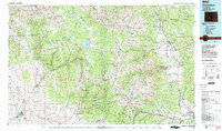
1984 Map of Gunnison
USGS Topo · Published 1984About this map
The Sawatch Range and the Elk Mountains dominate this 1984 study, defined by the high-altitude divide separating the Arkansas River and Gunnison River watersheds. The Continental Divide winds through the center of the sheet, surrounded by some of Colorado's highest peaks, including Mount Harvard, Mount Yale, and Mount Princeton. Higher-elevation settlements such as Tincup, Pitkin, and St Elmo are documented alongside established valley centers like Gunnison and Salida. In the southwest, Western State College stands at the edge of the Gunnison township, while the Taylor Park Reservoir serves as a major hydrologic feature in the central highlands. Transportation through these mountain passes is anchored by the Denver and Rio Grande Western Railroad and major routes like U S 50, illustrating the connectivity between the ranching and mining communities of the western slope and the commercial hubs of the Arkansas Valley.
Find a feature on this map
103 named features on this map. Tap any name to fly to it.
Don’t see what you’re looking for? This feature index may not catch every label — zoom into the map to look around manually.
Map Details
Editions of this 1984 Gunnison Map
2 editions found
Other maps of this area

1888 · Crested Butte
USGS Topo · 1:62,500

1888 · Anthracite
USGS Topo · 1:62,500

1889 · Crested Butte
USGS Topo · 1:62,500

1889 · Anthracite
USGS Topo · 1:62,500

1889 · Leadville
USGS Topo · 1:125,000

1891 · Leadville
USGS Topo · 1:125,000

1893 · Anthracite
USGS Topo · 1:62,500

1893 · Crested Butte
USGS Topo · 1:62,500

1893 · Aspen
USGS Topo · 1:62,500

1894 · Anthracite
USGS Topo · 1:62,500