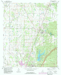
1992 Map of Guntown
USGS Topo · Published 1995About this map
The boundary between Union Co and Lee Co cuts through a landscape of creek bottoms and ridgelines in this early 1990s survey of northeast Mississippi. Settled communities like Guntown, Saltillo, and Baldwyn are documented alongside a web of rural institutions, including St Thomas Aquinas Ch Cem and Euclautubba Ch. The topography is defined by the winding course of Euclautubba Creek and the prominence of Pea Ridge, which overlooks the waters of Lake Lamar Bruce. Notable local infrastructure at this time includes a rail line marked as Under Construction and the iconic Natchez Trace Parkway bordering the western edge of the quadrangle. For genealogists and local historians, the map preserves the exact locations of family-named landmarks like Gaston Cem and Smith Cem, providing a precise record of the county’s physical and social development before late-century growth.
Find a feature on this map
48 named features on this map. Tap any name to fly to it.
Don’t see what you’re looking for? This feature index may not catch every label — zoom into the map to look around manually.
Map Details
Editions of this 1992 Guntown Map
This is the sole edition of this map. No revisions or reprints were ever made.
Other maps of this area

1921 · Booneville
USGS Topo · 1:48,000

1921 · Tupelo
USGS Topo · 1:48,000

1922 · Booneville
USGS Topo · 1:62,500

1923 · Tupelo
USGS Topo · 1:62,500

1955 · Ripley
USGS Topo · 1:62,500

1955 · Sherman
USGS Topo · 1:62,500

1956 · Tupelo
USGS Topo · 1:250,000

1958 · Tupelo
USGS Topo · 1:250,000

1965 · Mooreville
USGS Topo · 1:24,000

1973 · Guntown
USGS Topo · 1:24,000