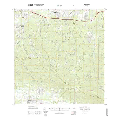
2018 Map of Gurabo
USGS Topo · Published 2018About this map
The hills and river valleys between Gurabo and Carolina define this interior landscape, where urban expansion meets the protected slopes of El Yunque National Forest. The map documents a complex network of municipal and rural cemeteries, including Cementerio Municipal Gurabo 2, Cementerio Rural de Gurabo, and the Cementerio Santa Cruz de Carolina. The terrain is characterized by prominent ridges like Chuchilla de Hato Nuevo and Cuchilla el Asomante, which overlook the winding course of the Rio Grande De Loiza. Residential growth is evident in settlements like Campo Rico and Trujillo Alto, while traditional land use persists near the forest boundary at Benitez. Numerous mountain streams, such as Quebrada Infierno and Quebrada Limones, drain the high ground, illustrating the hydrological connection between these central peaks and the northern coast.
Find a feature on this map
47 named features on this map. Tap any name to fly to it.
Don’t see what you’re looking for? This feature index may not catch every label — zoom into the map to look around manually.
Map Details
Editions of this 2018 Gurabo Map
This is the sole edition of this map. No revisions or reprints were ever made.
Other maps of this area

1940 · Carolina
USGS Topo · 1:30,000

1941 · San Juan
USGS Topo · 1:30,000

1941 · Rio Grande
USGS Topo · 1:30,000

1941 · Carolina
USGS Topo · 1:30,000

1945 · El Yunque
USGS Topo · 1:30,000

1946 · El Yunque
USGS Topo · 1:30,000

1946 · Aguas Buenas
USGS Topo · 1:30,000

1946 · Humacao
USGS Topo · 1:30,000

1946 · Gurabo
USGS Topo · 1:30,000

1946 · Juncos
USGS Topo · 1:30,000
Featured Places
- Gurabo
- Mariana, Carolina
- Sector Goyo Márquez, Gurabo
- La Marina, Canóvanas
- Sector Fruto Alemán, Trujillo Alto