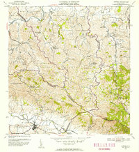
1955 Map of Gurabo
USGS Topo · Published 1956About this map
The town of Gurabo sits at the confluence of the Río Gurabo and Río Mamey, serving as a focal point for the surrounding barrios in the mid-1950s. The landscape is defined by the winding course of the Río Grande de Loíza and numerous named quebradas, such as Quebrada Infierno and Quebrada Maracuta, which carve through the prominent ridges of Cuchilla de Hato Nuevo and Cuchilla el Asomante.
Find a feature on this map
62 named features on this map. Tap any name to fly to it.
Don’t see what you’re looking for? This feature index may not catch every label — zoom into the map to look around manually.
Map Details
Editions of this 1955 Gurabo Map
This is the sole edition of this map. No revisions or reprints were ever made.
Other maps of this area

1940 · Carolina
USGS Topo · 1:30,000

1941 · San Juan
USGS Topo · 1:30,000

1941 · Rio Grande
USGS Topo · 1:30,000

1941 · Carolina
USGS Topo · 1:30,000

1945 · El Yunque
USGS Topo · 1:30,000

1946 · El Yunque
USGS Topo · 1:30,000

1946 · Aguas Buenas
USGS Topo · 1:30,000

1946 · Humacao
USGS Topo · 1:30,000

1946 · Gurabo
USGS Topo · 1:30,000

1946 · Juncos
USGS Topo · 1:30,000
Featured Places
- Gurabo
- La Marina, Canóvanas
- Sector Los Canales, Carolina
- Sector El Counte, Carolina
- Colinas de Cacao, Carolina