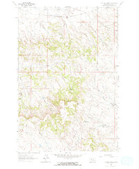
1962 Map of Guthridge Ranch
USGS Topo · Published 1965About this map
The Chicago Milwaukee St Paul and Pacific railroad traverses the northern reaches of this Rosebud County landscape, following the natural corridor of Home Creek. This early 1960s survey captures a ranching environment where water sources like Hildebrand Spring, Russell Spring, and West Muggins Creek dictate the placement of human activity. The map reveals the isolation of the Guthridge Ranch and other remote outposts, connected by unimproved dirt roads and a sprawling Pipeline network. Distinctive geological markers such as Eagle Rock and the prominent Muggins Gap serve as essential navigational landmarks in a region defined by complex drainage patterns and shifting elevations. Genealogists and local historians can find specific points of interest, including a marked Grave near the northern border and various remote Well sites that supported early 20th-century life.
Find a feature on this map
19 named features on this map. Tap any name to fly to it.
Don’t see what you’re looking for? This feature index may not catch every label — zoom into the map to look around manually.
Map Details
Editions of this 1962 Guthridge Ranch Map
2 editions found
Other maps of this area

1954 · Forsyth
USGS Topo · 1:250,000

1957 · Forsyth
USGS Topo · 1:250,000

1958 · Forsyth
USGS Topo · 1:250,000

1962 · Guthridge Ranch
USGS Topo · 1:24,000

1962 · Melstone NE
USGS Topo · 1:24,000

1962 · Sumatra
USGS Topo · 1:24,000

1962 · Grebe Ranch
USGS Topo · 1:24,000

1963 · Hecker Ranch
USGS Topo · 1:24,000

1963 · Melstone
USGS Topo · 1:24,000

1979 · Melstone
USGS Topo · 1:100,000