
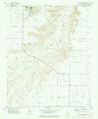
1968 Map of Guymon SW
USGS Topo · Published 1970About this map
Frisco Creek and Coldwater Creek carve paths through the high plains of the Oklahoma Panhandle, illustrating a landscape defined by water drainage and industrial expansion during the late 1960s. The map reveals a high density of gas wells scattered across the terrain, connected by a network of underground Pipeline infrastructure. Local economic activity is visible at the Hitch Ranch and several Sandpits, while a small Cem remains a quiet marker of early local heritage. Aviation and communication infrastructure, including Landing Strips and a Radio Tower, serve the surrounding ranching and drilling operations. This survey, conducted in cooperation with the Oklahoma Highway Department, documents the transition from traditional grazing lands to an intensive energy-producing region, right along the border of Texas Co and Hansford Co.
Find a feature on this map
11 named features on this map. Tap any name to fly to it.
Don’t see what you’re looking for? This feature index may not catch every label — zoom into the map to look around manually.
Map Details
Editions of this 1968 Guymon SW Map
This is the sole edition of this map. No revisions or reprints were ever made.
Other maps of this area

1954 · Perryton
USGS Topo · 1:250,000

1958 · Perryton
USGS Topo · 1:250,000

1968 · Guymon
USGS Topo · 1:24,000

1968 · Guymon NE
USGS Topo · 1:24,000

1968 · Guymon SE
USGS Topo · 1:24,000

1973 · Goodwell SE
USGS Topo · 1:24,000

1973 · Goodwell NE
USGS Topo · 1:24,000

1974 · Bernstein
USGS Topo · 1:24,000

1974 · Sunray 1 NE
USGS Topo · 1:24,000
1974 · Phillips Camp
USGS Topo · 1:24,000