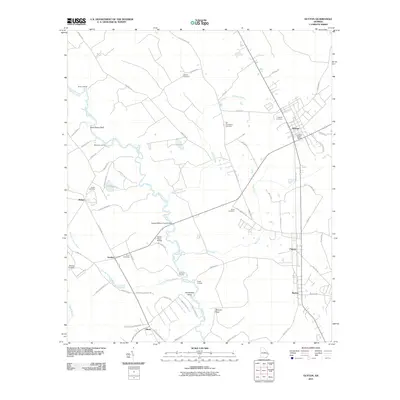
2011 Map of Guyton
USGS Topo · Published 2011About this map
The Ogeechee River snakes through this Georgia landscape, defining the western boundaries of rural Effingham County settlements in the early 21st century. The town of Guyton serves as the primary hub, where the Guyton Post Office and local streets like Magnolia St anchor the community near the Ferguson Cemetery. Moving south toward Pineora and Marlow, the terrain is characterized by a network of drainage creeks and historical family landmarks, including the Old Providence Cemetery and Elkins Cemetery. The river itself is a focal point for local geography, marked by distinct riverfront locations such as Saint Peters Bluff, Alderman Landing, and Horseshoe Bend. Transportation across these waters is facilitated by named structures like the Captain William Cone Bridge and the Doctor Floyd Bridge, which connect the scattered communities of Ivanhoe, Olney, and Hubert to the broader region via GA Highway 119.
Find a feature on this map
76 named features on this map. Tap any name to fly to it.
Don’t see what you’re looking for? This feature index may not catch every label — zoom into the map to look around manually.
Map Details
Editions of this 2011 Guyton Map
This is the sole edition of this map. No revisions or reprints were ever made.
Other maps of this area

1919 · Egypt
USGS Topo · 1:62,500

1920 · Pembroke
USGS Topo · 1:62,500

1920 · Meldrim
USGS Topo · 1:62,500

1921 · Brooklet
USGS Topo · 1:62,500

1939 · Egypt
USGS Topo · 1:62,500

1942 · Meldrim
USGS Topo · 1:62,500

1943 · Brooklet
USGS Topo · 1:62,500

1943 · Egypt
USGS Topo · 1:62,500

1947 · Savannah
USGS Topo · 1:250,000

1948 · Savannah
USGS Topo · 1:250,000