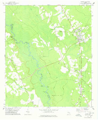
1978 Map of Guyton
USGS Topo · Published 1978About this map
The Ogeechee River defines the western border of this region, meandering past a series of riverfront access points including St Peters Bluff, Alderman Landing, and Joe Cone Landing. This landscape in the late 1970s is a mix of dense wetlands and upland settlements, where the river's winding path through Horseshoe Bend contrasts with the linear development along the eastern corridor. The community of Guyton stands as a primary hub, featuring the County Training Sch and several historic congregations like Macedonia Ch and New Hope Ch.
Find a feature on this map
37 named features on this map. Tap any name to fly to it.
Don’t see what you’re looking for? This feature index may not catch every label — zoom into the map to look around manually.
Map Details
Editions of this 1978 Guyton Map
This is the sole edition of this map. No revisions or reprints were ever made.
Other maps of this area

1919 · Egypt
USGS Topo · 1:62,500

1920 · Pembroke
USGS Topo · 1:62,500

1920 · Meldrim
USGS Topo · 1:62,500

1921 · Brooklet
USGS Topo · 1:62,500

1939 · Egypt
USGS Topo · 1:62,500

1942 · Meldrim
USGS Topo · 1:62,500

1943 · Brooklet
USGS Topo · 1:62,500

1943 · Egypt
USGS Topo · 1:62,500

1947 · Savannah
USGS Topo · 1:250,000

1948 · Savannah
USGS Topo · 1:250,000