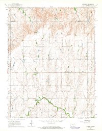
1964 Map of Gypsum SE
USGS Topo · Published 1965About this map
Elm Springs sits at the heart of this agricultural region on the border of Marion and Dickinson counties, surrounded by a dense network of early rural social centers. The landscape is defined by the winding course of the North Cottonwood River and Gypsum Creek, which supported a series of localized communities and family-named landmarks. Faith and family history are prominently visible through several rural churches and resting places, including Friedenstal Ch, Logan Ch, and the Pankratz Cem.
Find a feature on this map
28 named features on this map. Tap any name to fly to it.
Don’t see what you’re looking for? This feature index may not catch every label — zoom into the map to look around manually.
Map Details
Editions of this 1964 Gypsum SE Map
3 editions found
Other maps of this area

1889 · Newton
USGS Topo · 1:125,000

1889 · Abilene
USGS Topo · 1:125,000

1894 · Newton
USGS Topo · 1:125,000

1894 · Abilene
USGS Topo · 1:125,000

1955 · Gypsum
USGS Topo · 1:24,000

1955 · Hutchinson
USGS Topo · 1:250,000

1959 · Hutchinson
USGS Topo · 1:250,000

1964 · Elmo
USGS Topo · 1:24,000

1964 · Carlton
USGS Topo · 1:24,000
1964 · Tampa
USGS Topo · 1:24,000