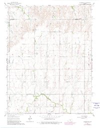
1964 Map of Gypsum SE
USGS Topo · Published 1980About this map
Elm Springs sits at the heart of this rural landscape, which transitioned from mid-century agricultural patterns to updated infrastructure by the late 1970s. The terrain is defined by the headwaters of several drainages, notably the North Cottonwood River and Holland Creek. Local history is deeply embedded in the land through numerous small community centers and burial grounds, such as Elm Springs Ch, Logan Ch, and the Friedental Cem.
Find a feature on this map
24 named features on this map. Tap any name to fly to it.
Don’t see what you’re looking for? This feature index may not catch every label — zoom into the map to look around manually.
Map Details
Editions of this 1964 Gypsum SE Map
3 editions found
Other maps of this area

1889 · Newton
USGS Topo · 1:125,000

1889 · Abilene
USGS Topo · 1:125,000

1894 · Newton
USGS Topo · 1:125,000

1894 · Abilene
USGS Topo · 1:125,000

1955 · Gypsum
USGS Topo · 1:24,000

1955 · Hutchinson
USGS Topo · 1:250,000

1959 · Hutchinson
USGS Topo · 1:250,000

1964 · Elmo
USGS Topo · 1:24,000

1964 · Carlton
USGS Topo · 1:24,000
1964 · Gypsum SE
USGS Topo · 1:24,000