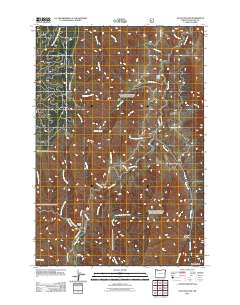
2011 Map of Haas Hollow
USGS Topo · Published 2011About this map
Corral Creek Ranch and Austin Ranch stand as isolated landmarks within the deep drainages of Wallowa County. The landscape is defined by the winding course of the Imnaha River, which serves as the primary hydrological artery for dozens of steep tributaries including Corral Creek, Buck Creek, and the Stubblefield Fork. Transport across this difficult terrain is limited to a handful of primary access routes such as Buckhorn Rd and the appropriately named Dug Bar Rd, which navigates the ridges above Packsaddle Creek. The density of named water features like Log Creek and East Fork Fence Creek versus the scarcity of settlements illustrates a remote cattle-ranching environment where life followed the natural contours of the river canyons and high hollows like Haas Hollow.
Find a feature on this map
36 named features on this map. Tap any name to fly to it.
Don’t see what you’re looking for? This feature index may not catch every label — zoom into the map to look around manually.
Map Details
Editions of this 2011 Haas Hollow Map
This is the sole edition of this map. No revisions or reprints were ever made.
Other maps of this area

1954 · Imnaha
USGS Topo · 1:62,500

1954 · Kernan Point
USGS Topo · 1:62,500

1955 · Grangeville
USGS Topo · 1:250,000

1959 · Grangeville
USGS Topo · 1:250,000

1963 · Cactus Mtn
USGS Topo · 1:24,000

1963 · Deadhorse Ridge
USGS Topo · 1:24,000

1963 · Poison Point
USGS Topo · 1:24,000

1980 · Grangeville
USGS Topo · 1:100,000

1990 · Imnaha
USGS Topo · 1:24,000
1990 · Sleepy Ridge
USGS Topo · 1:24,000