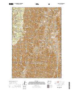
2020 Map of Haas Hollow
USGS Topo · Published 2020About this map
The Imnaha Wild and Scenic River carves through the heart of this landscape within the Wallowa National Forest, defining a drainage system where water and topography dictate the movement of people and wildlife. The elevation is marked by prominent named landforms including Grizzly Ridge and Haas Ridge, with the latter overlooking the eponymous Haas Hollow. This 2020 survey illustrates a sparsely developed region where human presence is largely limited to infrastructure like the Lower Imnaha Rimrock Rd, which follows the high ground above the river canyon. Numerous seasonal and perennial water sources such as Packsaddle Spring, Thorn Creek, and Fence Cr descend from the ridges, feeding into the primary Imnaha drainage. The map provides a contemporary record of local place names like Knapper Gulch and Pileup Canyon, which speak to the long history of livestock management and regional navigation in this part of Wallowa County.
Find a feature on this map
42 named features on this map. Tap any name to fly to it.
Don’t see what you’re looking for? This feature index may not catch every label — zoom into the map to look around manually.
Map Details
Editions of this 2020 Haas Hollow Map
This is the sole edition of this map. No revisions or reprints were ever made.
Other maps of this area

1954 · Imnaha
USGS Topo · 1:62,500

1954 · Kernan Point
USGS Topo · 1:62,500

1955 · Grangeville
USGS Topo · 1:250,000

1959 · Grangeville
USGS Topo · 1:250,000

1963 · Cactus Mtn
USGS Topo · 1:24,000

1963 · Deadhorse Ridge
USGS Topo · 1:24,000

1963 · Poison Point
USGS Topo · 1:24,000

1980 · Grangeville
USGS Topo · 1:100,000

1990 · Imnaha
USGS Topo · 1:24,000
1990 · Sleepy Ridge
USGS Topo · 1:24,000