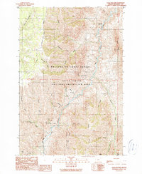
1990 Map of Haas Hollow
USGS Topo · Published 1990About this map
The Imnaha River carves a deep path through this corner of the Wallowa National Forest, serving as the primary geographical focus of the region. The landscape is defined by its complex drainage network, where the river is fed by numerous tributaries including Stubblefield Fork, Packsaddle Creek, and Buck Creek. Within the Hells Canyon National Recreation Area, human presence is marked by essential forest infrastructure like the Thorn Creek Guard Station and a system of primitive access routes such as Imnaha Road and Dug Bar Road. The terrain transitions from high points like Grizzly Ridge and Haas Ridge down into deep incisions such as Pileup Canyon. This 1990 provisional map documents a remote part of Oregon's northeastern corner, showing how the river and its many forks, such as Corral Fork and Dry Lake Fork, dictate the movement and management of this protected wilderness.
Find a feature on this map
32 named features on this map. Tap any name to fly to it.
Don’t see what you’re looking for? This feature index may not catch every label — zoom into the map to look around manually.
Map Details
Editions of this 1990 Haas Hollow Map
This is the sole edition of this map. No revisions or reprints were ever made.
Other maps of this area

1954 · Imnaha
USGS Topo · 1:62,500

1954 · Kernan Point
USGS Topo · 1:62,500

1955 · Grangeville
USGS Topo · 1:250,000

1959 · Grangeville
USGS Topo · 1:250,000

1963 · Cactus Mtn
USGS Topo · 1:24,000

1963 · Deadhorse Ridge
USGS Topo · 1:24,000

1963 · Poison Point
USGS Topo · 1:24,000

1980 · Grangeville
USGS Topo · 1:100,000

1990 · Imnaha
USGS Topo · 1:24,000
1990 · Sleepy Ridge
USGS Topo · 1:24,000