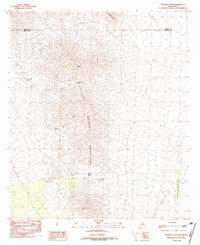
1982 Map of Hachita
USGS Topo · Published 1982About this map
The Little Hatchet Mountains dominate this 1982 survey, straddling the border of Grant and Hidalgo counties. This arid landscape is defined by its verticality, rising from the Hachita Valley up to the high point at Hachita Peak. The presence of a Mine Shaft and multiple Prospects throughout the range indicates a history of mineral exploration in these remote slopes, while Stone Cabin Gulch suggests a human footprint of early settlement or seasonal activity. Water remains a critical element for survival and livestock in this environment, with Cottonwood Spring providing a rare named source on the western flank of the range. Travelers through the mountains would have relied on topographical landmarks like Broken Jug Pass and Howells Ridge to navigate the high ground between the desert basins.
Find a feature on this map
11 named features on this map. Tap any name to fly to it.
Don’t see what you’re looking for? This feature index may not catch every label — zoom into the map to look around manually.
Map Details
Editions of this 1982 Hachita Map
2 editions found
Other maps of this area

1918 · Hachita
USGS Topo · 1:62,500

1918 · Victorio
USGS Topo · 1:62,500

1954 · Silver City
USGS Topo · 1:250,000

1955 · Douglas
USGS Topo · 1:250,000

1958 · Silver City
USGS Topo · 1:250,000

1959 · Douglas
USGS Topo · 1:250,000

1961 · Douglas
USGS Topo · 1:250,000

1962 · Silver City
USGS Topo · 1:250,000

1963 · Gage SW
USGS Topo · 1:24,000

1964 · Douglas
USGS Topo · 1:250,000