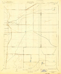
1929 Map of Hacienda Ranch
USGS Topo · Published 1942About this map
The irrigated plains of the San Joaquin Valley appear in this 1929 study, showing the intersection of Kings, Kern, and Tulare counties. The landscape is defined by the early reclamation and water management systems necessary for large-scale ranching, featuring the Homeland Canal and Goose Lake Canal. These water systems supported several major family operations including Hacienda Ranch, Bent Ranch, and Fowler Ranch. In the southern portion of the sheet, the presence of the Westlake Gun Club suggests the seasonal wetlands that remained amidst the deepening agricultural footprint. The sparse network of thoroughfares, including Corcoran Road and Lost Hills Road, highlights the remote character of these ranchlands during the interwar years, before more intensive development altered the basin.
Find a feature on this map
11 named features on this map. Tap any name to fly to it.
Don’t see what you’re looking for? This feature index may not catch every label — zoom into the map to look around manually.
Map Details
Editions of this 1929 Hacienda Ranch Map
2 editions found
Other maps of this area

1914 · Lost Hills
USGS Topo · 1:125,000

1929 · Alpaugh
USGS Topo · 1:31,680

1929 · Hacienda Ranch
USGS Topo · 1:31,680

1929 · West Alpaugh
USGS Topo · 1:31,680

1929 · Allensworth
USGS Topo · 1:31,680

1930 · Hamlin School
USGS Topo · 1:31,680

1930 · Miramonte Ranch
USGS Topo · 1:31,680

1931 · Harvester
USGS Topo · 1:31,680

1932 · Reynolds Ranch
USGS Topo · 1:31,680

1932 · Lone Tree Well
USGS Topo · 1:31,680