
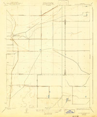
1929 Map of Hacienda Ranch
USGS Topo · Published 1929About this map
Hacienda Ranch sits at the intersection of early twentieth-century agriculture and hydraulic engineering in the southern San Joaquin Valley. This 1920s landscape is defined by the managed flow of the Homeland Canal and the presence of Goose Lake, reflecting a period when water rights and irrigation were transforming this arid basin into productive ranching territory. Prominent family-named holdings such as Bent Ranch, Hacienda Ranch, and Fowler Ranch dominate the map, illustrating the scale of land ownership during this era. The quadrangle captures a complex jurisdictional point where the boundaries of Kings, Tulare, and Kern counties meet. Regional connectivity is established by the straight trajectories of Corcoran Road and Lost Hills Road, while the inclusion of the Westlake Gun Club suggests the recreational use of the valley's wetlands alongside its industrial agricultural development.
Find a feature on this map
11 named features on this map. Tap any name to fly to it.
Don’t see what you’re looking for? This feature index may not catch every label — zoom into the map to look around manually.
Map Details
Editions of this 1929 Hacienda Ranch Map
2 editions found
Other maps of this area

1914 · Lost Hills
USGS Topo · 1:125,000

1929 · Alpaugh
USGS Topo · 1:31,680

1929 · West Alpaugh
USGS Topo · 1:31,680

1929 · Allensworth
USGS Topo · 1:31,680

1930 · Hamlin School
USGS Topo · 1:31,680

1930 · Miramonte Ranch
USGS Topo · 1:31,680

1931 · Harvester
USGS Topo · 1:31,680

1932 · Reynolds Ranch
USGS Topo · 1:31,680

1932 · Lone Tree Well
USGS Topo · 1:31,680
1935 · Harvester
USGS Topo · 1:31,680