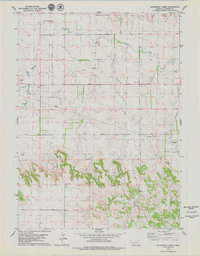
1979 Map of Hackberry Creek
USGS Topo · Published 1979About this map
The Bighorn Oil Field dominates the northwest corner of this Banner County landscape, where numerous Oil Wells and Drill Holes indicate the active energy extraction of the late 1970s. The terrain transitions from the open plains of Pumpkin Creek in the north toward more complex drainage patterns to the south. Local heritage is anchored by sites like Kirk Cem and Chalk Creek Cem, which provide specific points of interest for genealogists tracing early families in the region. The map also records the natural landmarks of the area, including Chalk Mound and the deep cut of Bighorn Gulch. This survey captures a moment when traditional ranching and petroleum development overlapped, evidenced by the intricate network of fence lines and access roads connecting various springs and remote drill sites.
Find a feature on this map
12 named features on this map. Tap any name to fly to it.
Don’t see what you’re looking for? This feature index may not catch every label — zoom into the map to look around manually.
Map Details
Editions of this 1979 Hackberry Creek Map
This is the sole edition of this map. No revisions or reprints were ever made.
Other maps of this area

1898 · Scotts Bluff
USGS Topo · 1:125,000

1898 · Camp Clarke
USGS Topo · 1:125,000

1954 · Scottsbluff
USGS Topo · 1:250,000

1958 · Scottsbluff
USGS Topo · 1:250,000

1965 · South Bayard
USGS Topo · 1:24,000

1965 · McGrew
USGS Topo · 1:24,000

1973 · Scotts Bluff 4 SE
USGS Topo · 1:24,000

1973 · Scotts Bluff 4 NE
USGS Topo · 1:24,000

1973 · Kimball 1 NE
USGS Topo · 1:24,000

1973 · Potter 2 NW
USGS Topo · 1:24,000