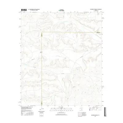
2016 Map of Hackberry Draw SE
USGS Topo · Published 2016About this map
Independence Cr and its N Fork Independence Cr carve a network of drainage patterns across this West Texas landscape along the border of Pecos and Terrell counties. The terrain is defined by the namesake Hackberry Draw, a significant geographic feature that dictates the path of local transport. Ranching infrastructure dominates the human footprint here, with established routes such as Porter Ranch Rd, Gray Ranch Rd, and Edwards Rd providing access to remote acreage. The intersection of Ranch Rd 2886 and FM 2886 serves as a primary corridor through this sparsely populated region. This survey captures the land as it appeared in the mid-2010s, reflecting a landscape where the ancient watercourses of the Trans-Pecos continue to shape modern ranching boundaries and road networks.
Find a feature on this map
9 named features on this map. Tap any name to fly to it.
Don’t see what you’re looking for? This feature index may not catch every label — zoom into the map to look around manually.
Map Details
Editions of this 2016 Hackberry Draw SE Map
This is the sole edition of this map. No revisions or reprints were ever made.
Other maps of this area

1928 · Sanderson
USGS Topo · 1:125,000

1929 · Independence Draw Quadrangle
USGS Topo · 1:125,000

1954 · Fort Stockton
USGS Topo · 1:250,000

1958 · Fort Stockton
USGS Topo · 1:250,000

1969 · Circle Dot Ranch
USGS Topo · 1:24,000

1969 · Big Canyon Ranch NW
USGS Topo · 1:24,000
1969 · Seventeen Ranch
USGS Topo · 1:24,000

1969 · Hackberry Draw NW
USGS Topo · 1:24,000

1969 · Hackberry Draw NE
USGS Topo · 1:24,000
1969 · Hackberry Draw SE
USGS Topo · 1:24,000