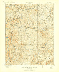
1915 Map of Hacker Valley
USGS Topo · Published 1951About this map
The Lumber RR and Baltimore and Ohio RR anchor the industrial landscape of this West Virginia mountain region just before the first World War. Extensive timber operations are evident through the numerous railroads and specialized settlements like Hacker Valley and Arvondale Junc. The terrain is characterized by steep ridges and deep runs, with the Elk River and Little Kanawha River carving through the Highlands.
Find a feature on this map
122 named features on this map. Tap any name to fly to it.
Don’t see what you’re looking for? This feature index may not catch every label — zoom into the map to look around manually.
Map Details
Editions of this 1915 Hacker Valley Map
4 editions found

Other maps of this area

1889 · Nicholas
USGS Topo · 1:125,000

1891 · Nicholas
USGS Topo · 1:125,000

1891 · Huntersville
USGS Topo · 1:125,000

1893 · Buckhannon
USGS Topo · 1:125,000

1893 · Sutton
USGS Topo · 1:125,000

1894 · Huntersville
USGS Topo · 1:125,000

1896 · Buckhannon
USGS Topo · 1:125,000

1897 · Buckhannon
USGS Topo · 1:125,000

1901 · Nicholas
USGS Topo · 1:125,000

1906 · Burnsville
USGS Topo · 1:62,500