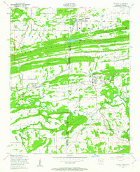
1948 Map of Hackett
USGS Topo · Published 1963About this map
Industrial activity and ridge-and-valley terrain define this borderland where Le Flore and Sebastian counties meet along the Oklahoma-Arkansas line. Extensive strip mines and coal deposits surround the town of Hackett, while a complex rail network including the Louis San Francisco railroad serves the settlements of Bonanza and Rock Island. The landscape is dominated by significant geographic barriers like Backbone Mountain and Gray Mountain, which separate the Pocola Valley from the northern mining districts.
Find a feature on this map
35 named features on this map. Tap any name to fly to it.
Don’t see what you’re looking for? This feature index may not catch every label — zoom into the map to look around manually.
Map Details
Editions of this 1948 Hackett Map
3 editions found

Other maps of this area

1879 · Fort Smith
USGS Topo · 1:62,500

1887 · Van Buren
USGS Topo · 1:62,500

1887 · Greenwood
USGS Topo · 1:62,500

1890 · Fort Smith
USGS Topo · 1:125,000

1900 · Sallisaw
USGS Topo · 1:125,000

1911 · Sallisaw
USGS Topo · 1:125,000

1943 · Fort Smith
USGS Topo · 1:125,000

1946 · Fort Smith
USGS Topo · 1:250,000

1947 · Van Buren
USGS Topo · 1:62,500

1947 · Greenwood
USGS Topo · 1:62,500