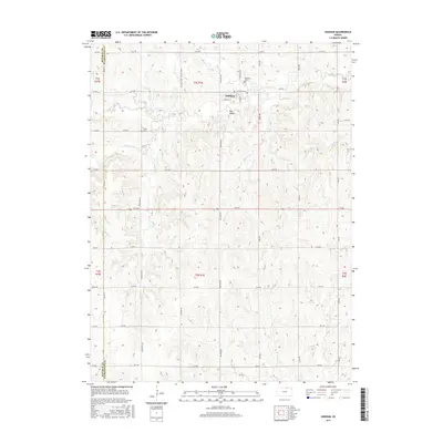
2015 Map of Haddam
USGS Topo · Published 2015About this map
Haddam serves as the central hub of this agricultural landscape in Washington County, organized by a precise grid of rural routes like 20th Rd and Co Rd N. The terrain is defined by the intricate dendritic drainage patterns of the Mill Creek watershed, where the N Fork Mill Cr and S Fork Mill Cr converge. These waterways, along with others like Mulberry Cr and Turkey Cr, carve through the rolling plains, creating a complex topography that dictated the placement of early homesteads and transport lines. For those researching local history, the map provides the exact locations of Haddam Cem and Oliver Cem, alongside the named area of Hay Valley. The boundary between Republic Co and Washington Co runs along the western edge, marking a significant political and cadastral divide in this portion of northern Kansas.
Find a feature on this map
40 named features on this map. Tap any name to fly to it.
Don’t see what you’re looking for? This feature index may not catch every label — zoom into the map to look around manually.
Map Details
Editions of this 2015 Haddam Map
This is the sole edition of this map. No revisions or reprints were ever made.
Other maps of this area

1893 · Washington
USGS Topo · 1:125,000

1955 · Manhattan
USGS Topo · 1:250,000

1956 · Manhattan
USGS Topo · 1:250,000

1957 · Manhattan
USGS Topo · 1:250,000

1965 · Brantford
USGS Topo · 1:24,000

1965 · Agenda
USGS Topo · 1:24,000
1966 · Washington NW
USGS Topo · 1:24,000

1966 · Morrowville
USGS Topo · 1:24,000
1966 · Narka
USGS Topo · 1:24,000
1966 · Haddam
USGS Topo · 1:24,000