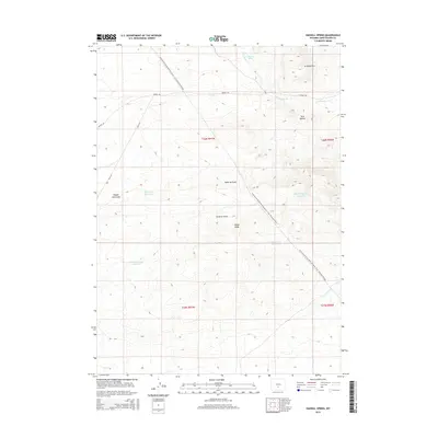
2015 Map of Hadsell Spring
USGS Topo · Published 2015About this map
The Continental Divide National Scenic Trail- Wyoming Portion traverses this high-desert landscape in Sweetwater County, crossing a terrain defined by intermittent drainages and critical water sources. Named landmarks like Stratton Rim and the Twin Buttes rise above a series of draws, including Osborne Draw and Stratton Draw. The necessity of water management in this arid region is evident through several catchments, such as Pinnacle Springs Reservoir, Dry Well Reservoir, and Rocky Draw Reservoir. Access through this territory is maintained by Bairoil Rd and several Bureau of Land Management routes like Blm-3215, which serve the various springs and natural features like Hadsell Spring and Lost Soldier Cr. The map captures a section of the divide where seasonal creek beds and topographic variations dictate the local geography.
Find a feature on this map
20 named features on this map. Tap any name to fly to it.
Don’t see what you’re looking for? This feature index may not catch every label — zoom into the map to look around manually.
Map Details
Editions of this 2015 Hadsell Spring Map
This is the sole edition of this map. No revisions or reprints were ever made.
Other maps of this area

1955 · Casper
USGS Topo · 1:250,000

1958 · Casper
USGS Topo · 1:250,000

1960 · Sooner Reservoir
USGS Topo · 1:24,000

1960 · Bull Springs
USGS Topo · 1:24,000

1960 · Chicken Spring
USGS Topo · 1:24,000
1961 · Osborne Well
USGS Topo · 1:24,000

1961 · Hadsell Spring
USGS Topo · 1:24,000

1961 · Crooks Peak
USGS Topo · 1:24,000

1961 · Bairoil
USGS Topo · 1:24,000

1962 · Casper
USGS Topo · 1:250,000