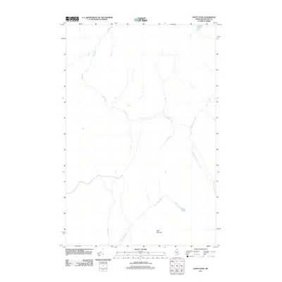
2011 Map of Hafey Pond
USGS Topo · Published 2011About this map
Hafey Mountain anchors the southern portion of this northern Maine landscape, overseeing a network of cold-water streams that define the region's hydrology. The terrain is characterized by the winding path of Dead Brook, which meanders through the central and northwestern reaches, and the distinct flow of Yankeetuladi Brook along the eastern edge. This area, located in the remote Big Twenty Township of Aroostook County, remains largely defined by its natural features rather than settlement, showing a landscape dedicated to forestry and wilderness. Water bodies like Hafey Pond and the smaller Jones Pond in the northeast provide critical landmarks for those navigating the backcountry. The absence of established towns reflects the area's history as working timberland, where Hafey Brook and Little Hafey Brook serve as the primary geographical markers in an otherwise dense wilderness.
Find a feature on this map
7 named features on this map. Tap any name to fly to it.
Don’t see what you’re looking for? This feature index may not catch every label — zoom into the map to look around manually.
Map Details
Editions of this 2011 Hafey Pond Map
This is the sole edition of this map. No revisions or reprints were ever made.
Other maps of this area

1930 · Allagash
USGS Topo · 1:48,000

1933 · Allagash
USGS Topo · 1:62,500

1955 · Rocky Mountain
USGS Topo · 1:62,500

1955 · Rocky Brook
USGS Topo · 1:62,500

1955 · Beau Lake
USGS Topo · 1:62,500

1962 · Edmundston
USGS Topo · 1:250,000
1986 · Landry
USGS Topo · 1:24,000

1987 · Beau Lake
USGS Topo · 1:24,000
1987 · Johnson Brook Mountain
USGS Topo · 1:24,000

1987 · Hafey Pond
USGS Topo · 1:24,000