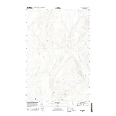
2014 Map of Hafey Pond
USGS Topo · Published 2014About this map
Hafey Mtn and Boat Landing Mtn anchor this remote landscape in Big Twenty Township, Maine, where a network of unpaved forest roads and seasonal camps defines the human presence. In the early 21st century, the terrain is characterized by a dense drainage system feeding into isolated water bodies like Hafey Pond and Jones Pond. The naming of Landry Rd, Red Camp Rd, and Jones Pond Rd suggests a landscape shaped by logging interests and private sporting traditions. Tracing the courses of Yankeetuladi Brook, Little Hafey Brook, and Hafey Rd reveals the intricate topography of the North Maine Woods, providing a detailed look at the hydrology of the upper Saint John River watershed.
Find a feature on this map
11 named features on this map. Tap any name to fly to it.
Don’t see what you’re looking for? This feature index may not catch every label — zoom into the map to look around manually.
Map Details
Editions of this 2014 Hafey Pond Map
This is the sole edition of this map. No revisions or reprints were ever made.
Other maps of this area

1930 · Allagash
USGS Topo · 1:48,000

1933 · Allagash
USGS Topo · 1:62,500

1955 · Rocky Mountain
USGS Topo · 1:62,500

1955 · Rocky Brook
USGS Topo · 1:62,500

1955 · Beau Lake
USGS Topo · 1:62,500

1962 · Edmundston
USGS Topo · 1:250,000
1986 · Landry
USGS Topo · 1:24,000

1987 · Beau Lake
USGS Topo · 1:24,000
1987 · Johnson Brook Mountain
USGS Topo · 1:24,000

1987 · Hafey Pond
USGS Topo · 1:24,000