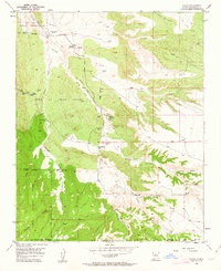
1954 Map of Hagan
USGS Topo · Published 1963About this map
Abandoned mining settlements and ancestral ruins characterize this 1954 landscape in the San Pedro and Tejon land grants. The map documents the remnants of a coal-mining era, specifically naming the Hagan (Ghost Town) and Coyote (Ghost Town), which are connected by the San Pedro Old Railroad Grade. Further west, the Town of Tejon Grant contains the Tejon (Ghost Town) and its associated Tejon Cemetery, while the northern portion of the sheet reveals the archaeological footprint of Tonque Pueblo (Ruins) near Arroyo Tonque. This survey provides an essential look at the region after the decline of the local coal industry, preserving the locations of Abandoned Coal Mines and the Uña de Gato (Site) Cem before natural erosion and time further obscured these sites. The rugged geography is defined by deep cuts like Canyon Tejon and the sprawling drainages of the San Pedro Creek.
Find a feature on this map
34 named features on this map. Tap any name to fly to it.
Don’t see what you’re looking for? This feature index may not catch every label — zoom into the map to look around manually.
Map Details
Editions of this 1954 Hagan Map
Other maps of this area

1892 · San Pedro
USGS Topo · 1:125,000

1954 · Sandia Crest
USGS Topo · 1:24,000

1954 · San Felipe Pueblo
USGS Topo · 1:24,000

1954 · Placitas
USGS Topo · 1:24,000

1954 · Sandia Park
USGS Topo · 1:24,000

1954 · San Pedro
USGS Topo · 1:24,000

1954 · San Felipe Pueblo NE
USGS Topo · 1:24,000

1954 · Hagan
USGS Topo · 1:24,000

1954 · San Felipe Pueblo
USGS Topo · 1:62,500

1956 · Edgewood
USGS Topo · 1:62,500