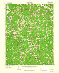
1962 Map of Hager
USGS Topo · Published 1964About this map
The Mud River winds through the heart of Lincoln County, defining the settlement patterns of this central West Virginia landscape during the early 1960s. Small communities like Myra, Hager, and Palermo are established along the valley floor, while a dense network of country churches and schools serves the surrounding rural districts of Union, Carroll, and Duval. The map documents a topography marked by a significant Gas Field, with numerous Gas Wells scattered across the ridges and hollows, alongside the occasional Mine. Genealogy researchers will find substantial detail in the preservation of family names through landmarks like the Noah Sias Cem, Stowers-Adkins Cem, and Wellman Cem. This survey captures the region just as modern infrastructure, indicated by a prominent Pipeline, began to overlay the older road system of trails and jeep tracks.
Find a feature on this map
86 named features on this map. Tap any name to fly to it.
Don’t see what you’re looking for? This feature index may not catch every label — zoom into the map to look around manually.
Map Details
Editions of this 1962 Hager Map
This is the sole edition of this map. No revisions or reprints were ever made.
Other maps of this area

1892 · Huntington
USGS Topo · 1:125,000

1898 · Huntington
USGS Topo · 1:125,000

1899 · Charleston
USGS Topo · 1:125,000

1902 · Milton
USGS Topo · 1:62,500

1902 · Midkiff
USGS Topo · 1:62,500

1907 · Midkiff
USGS Topo · 1:62,500

1909 · Midkiff
USGS Topo · 1:62,500

1909 · Saint Albans
USGS Topo · 1:62,500

1911 · Madison
USGS Topo · 1:62,500

1929 · Madison
USGS Topo · 1:62,500