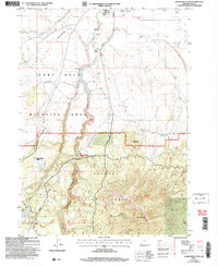
2004 Map of Hager Mountain
USGS Topo · Published 2007About this map
Hager Mountain Lookout stands as a primary sentinel over this high-elevation landscape in south-central Oregon. The transition from the flat, low-lying marshes and ranchlands near Silver Lake to the steep, forested slopes of Mahogany Mountain and Hager Mountain is sharply defined. The Fremont National Forest boundary divides the northern rangelands from the timbered heights, where the Fremont National Recreation Trail winds through the terrain. Evidence of rural infrastructure and water management is seen at the Gaging Station and Bunyard Crossing on Silver Creek, alongside several cinder and gravel pits that supported local road maintenance. The presence of the Chase Spring Administrative Reserve and a Communication Tower further marks this as a managed forest landscape, while family-named sites like Gowdy Ranch ground the map in the region's agricultural history.
Find a feature on this map
22 named features on this map. Tap any name to fly to it.
Don’t see what you’re looking for? This feature index may not catch every label — zoom into the map to look around manually.
Map Details
Editions of this 2004 Hager Mountain Map
This is the sole edition of this map. No revisions or reprints were ever made.
Other maps of this area

1889 · Klamath
USGS Topo · 1:250,000

1894 · Klamath
USGS Topo · 1:250,000

1955 · Crescent
USGS Topo · 1:250,000

1955 · Klamath Falls
USGS Topo · 1:250,000

1957 · Crescent
USGS Topo · 1:250,000

1958 · Crescent
USGS Topo · 1:250,000

1958 · Klamath Falls
USGS Topo · 1:250,000

1960 · Sycan Marsh
USGS Topo · 1:62,500

1966 · Foster Butte
USGS Topo · 1:24,000

1968 · Silver Lake
USGS Topo · 1:24,000