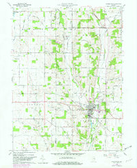
1960 Map of Hagerstown
USGS Topo · Published 1982About this map
Hagerstown anchors this agricultural landscape along the border of Henry and Wayne counties as it appeared in the early 1960s. The town's grid is bisected by the Norfolk and Western Pipeline and buffered by West Lawn Cem. To the north, the small settlement of Dalton serves as a rural hub, home to the Dalton Township Sch and the West River Ch. The terrain is defined by a dense network of small waterways including Nettle Creek, Symonds Creek, and the Whitewater River, which carve through the farmland. Local history is preserved in sites like the Wilbur Wright Memorial and numerous country parishes such as Brick Church and Chicago Corner Ch. This survey illustrates a period of established mid-century rural life before significant modern consolidation, documenting family-named landmarks like Nobblett Hill and several small, isolated cemeteries that mark the area's early genealogy.
Find a feature on this map
83 named features on this map. Tap any name to fly to it.
Don’t see what you’re looking for? This feature index may not catch every label — zoom into the map to look around manually.
Map Details
Editions of this 1960 Hagerstown Map
2 editions found
Other maps of this area

1948 · Lewisville
USGS Topo · 1:24,000

1950 · New Castle East
USGS Topo · 1:24,000

1950 · Lewisville
USGS Topo · 1:24,000

1953 · Cincinnati
USGS Topo · 1:250,000

1953 · Muncie
USGS Topo · 1:250,000

1956 · Muncie
USGS Topo · 1:250,000

1957 · Cincinnati
USGS Topo · 1:250,000

1960 · New Castle East
USGS Topo · 1:24,000

1960 · Mount Pleasant
USGS Topo · 1:24,000

1960 · Carlos
USGS Topo · 1:24,000