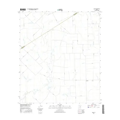
2016 Map of Hahn
USGS Topo · Published 2016About this map
The small settlement of Hahn and the nearby Hahn Cem anchor this 2016 topographical landscape along the Colorado and Wharton County border. The terrain is defined by a dense network of meandering waterways, including Pinoak Cr, Porters Cr, and W Mustang Cr, which navigate the coastal prairie. The area’s industrial character is indicated by Oil Field Rd, hinting at the energy extraction history common to this part of the Texas Gulf Coast. Transport across this rural expanse relies on a grid of county roads and farm-to-market routes like FM 1160 and FM 2546, which connect isolated homesteads and agricultural tracts. Further south, the map details the confluence of Lookout Cr and Sandy Cr, illustrating the complex drainage patterns that shape the local geography and land use.
Find a feature on this map
35 named features on this map. Tap any name to fly to it.
Don’t see what you’re looking for? This feature index may not catch every label — zoom into the map to look around manually.
Map Details
Editions of this 2016 Hahn Map
This is the sole edition of this map. No revisions or reprints were ever made.
Other maps of this area

1953 · Seguin
USGS Topo · 1:250,000

1958 · Seguin
USGS Topo · 1:250,000

1959 · Garwood
USGS Topo · 1:24,000

1959 · Bonus
USGS Topo · 1:24,000

1960 · New Taiton
USGS Topo · 1:24,000

1965 · El Campo
USGS Topo · 1:24,000
1965 · Sheridan NE
USGS Topo · 1:24,000

1965 · Ganado NE
USGS Topo · 1:24,000

1965 · Sheridan SE
USGS Topo · 1:24,000

1965 · Gobbler Creek
USGS Topo · 1:24,000