
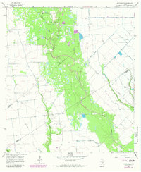
1965 Map of Sheridan SE
USGS Topo · Published 1967About this map
Sandy Creek meanders through this landscape, marking a wooded corridor where the boundaries of Colorado, Lavaca, and Wharton Counties meet. The mid-1960s terrain is defined by a sparse but active industrial footprint, with numerous Oil Wells and a Gas Well scattered across the coastal plains. This era shows the transition of rural Texas ranch land into a managed energy and aviation landscape, evidenced by small private aviation facilities like Whitegate Landing Strip and another unnamed Landing Strip further north.
Find a feature on this map
14 named features on this map. Tap any name to fly to it.
Don’t see what you’re looking for? This feature index may not catch every label — zoom into the map to look around manually.
Map Details
Editions of this 1965 Sheridan SE Map
2 editions found
Other maps of this area

1953 · Seguin
USGS Topo · 1:250,000

1958 · Seguin
USGS Topo · 1:250,000

1959 · Garwood
USGS Topo · 1:24,000

1964 · Cordele
USGS Topo · 1:24,000

1964 · Speaks
USGS Topo · 1:24,000
1965 · Sheridan NE
USGS Topo · 1:24,000

1965 · Ganado NE
USGS Topo · 1:24,000

1965 · Gobbler Creek
USGS Topo · 1:24,000
1965 · Sheridan
USGS Topo · 1:24,000
1965 · Hahn
USGS Topo · 1:24,000