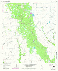
1965 Map of Sheridan SE
USGS Topo · Published 1983About this map
Sandy Creek carves a winding path through this Texas coastal plain landscape, marking the convergence of Colorado, Lavaca, and Wharton counties. The terrain is defined by a dense network of drainage systems, including the Lost Fork Goldenrod Creek and Middle Turkey Creek, which flow through an area increasingly shaped by energy extraction. Numerous Oil Well and Gas Well sites are scattered across the quadrangle, connected by a web of pipelines and elevated infrastructure.
Find a feature on this map
17 named features on this map. Tap any name to fly to it.
Don’t see what you’re looking for? This feature index may not catch every label — zoom into the map to look around manually.
Map Details
Editions of this 1965 Sheridan SE Map
2 editions found
Other maps of this area

1953 · Seguin
USGS Topo · 1:250,000

1958 · Seguin
USGS Topo · 1:250,000

1959 · Garwood
USGS Topo · 1:24,000

1964 · Cordele
USGS Topo · 1:24,000

1964 · Speaks
USGS Topo · 1:24,000
1965 · Sheridan NE
USGS Topo · 1:24,000

1965 · Ganado NE
USGS Topo · 1:24,000

1965 · Sheridan SE
USGS Topo · 1:24,000

1965 · Gobbler Creek
USGS Topo · 1:24,000
1965 · Sheridan
USGS Topo · 1:24,000