
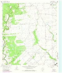
1964 Map of Cordele
USGS Topo · Published 1966About this map
The Navidad River carves a winding path along the western edge of this Jackson County landscape, defining the sharp turn at Gandy Bend. This mid-century survey reveals a rural Texas economy transitioning from traditional river-bottom agriculture toward energy extraction, centered on the Morales Gas Field. Extensive infrastructure including a Trunkline Pipeline, numerous Gas Wells, and a dedicated Landing Strip illustrate the industrial footprint of the era. Settlement is concentrated around the community of Cordele and the small outpost at Wayside, where the Wayside Chapel stands. Genealogists will find significant value in the documentation of family-named landmarks and burial sites, including Gandy Cem, Miller Cem, and Flourney Cem, which are scattered among the tributaries of Brushy Creek and Sandy Creek.
Find a feature on this map
27 named features on this map. Tap any name to fly to it.
Don’t see what you’re looking for? This feature index may not catch every label — zoom into the map to look around manually.
Map Details
Editions of this 1964 Cordele Map
2 editions found
Other maps of this area

1953 · Seguin
USGS Topo · 1:250,000

1958 · Seguin
USGS Topo · 1:250,000

1962 · Hallettsville SE
USGS Topo · 1:24,000

1963 · Ganado
USGS Topo · 1:24,000

1963 · Mount Olive
USGS Topo · 1:24,000

1964 · Morales
USGS Topo · 1:24,000

1964 · Speaks
USGS Topo · 1:24,000
1964 · Navidad
USGS Topo · 1:24,000

1965 · Ganado NE
USGS Topo · 1:24,000

1965 · Sheridan SE
USGS Topo · 1:24,000