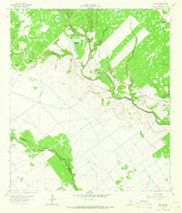
1964 Map of Navidad
USGS Topo · Published 1966About this map
The Lavaca River meanders through this portion of the Texas coastal plain, defining a landscape of oxbows and creek bottoms in the mid-1960s. The small settlement of Navidad sits near the riverbanks, surrounded by a network of rural family cemeteries that provide significant genealogical data, including Wilkerson Cem, Cox Cem, and McHenry Cem. The topography is marked by several named hollows like McCoy Hollow and Roden Hollow, which drain into the river's winding course.
Find a feature on this map
27 named features on this map. Tap any name to fly to it.
Don’t see what you’re looking for? This feature index may not catch every label — zoom into the map to look around manually.
Map Details
Editions of this 1964 Navidad Map
2 editions found
Other maps of this area

1951 · Inez NW
USGS Topo · 1:24,000

1951 · Inez
USGS Topo · 1:24,000

1952 · Edna
USGS Topo · 1:24,000

1953 · Beeville
USGS Topo · 1:250,000

1953 · Seguin
USGS Topo · 1:250,000

1956 · Beeville
USGS Topo · 1:250,000

1958 · Seguin
USGS Topo · 1:250,000

1960 · Beeville
USGS Topo · 1:250,000

1963 · Mount Olive
USGS Topo · 1:24,000

1964 · Cordele
USGS Topo · 1:24,000