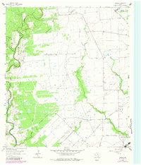
1964 Map of Cordele
USGS Topo · Published 1981About this map
The Navidad River carves a winding path through this corner of Jackson County, shaping the landscape at Gandy Bend and supporting the drainage of Sandy Creek and Brushy Creek. This area, updated in the early 1980s from mid-century surveys, reflects a rural economy balanced between traditional land use and energy extraction. The footprint of the Morales Gas Field is evident across the southern portion of the map, marked by numerous drill holes and a Pumping Sta.
Find a feature on this map
18 named features on this map. Tap any name to fly to it.
Don’t see what you’re looking for? This feature index may not catch every label — zoom into the map to look around manually.
Map Details
Editions of this 1964 Cordele Map
2 editions found
Other maps of this area

1953 · Seguin
USGS Topo · 1:250,000

1958 · Seguin
USGS Topo · 1:250,000

1962 · Hallettsville SE
USGS Topo · 1:24,000

1963 · Ganado
USGS Topo · 1:24,000

1963 · Mount Olive
USGS Topo · 1:24,000

1964 · Cordele
USGS Topo · 1:24,000

1964 · Morales
USGS Topo · 1:24,000

1964 · Speaks
USGS Topo · 1:24,000
1964 · Navidad
USGS Topo · 1:24,000

1965 · Ganado NE
USGS Topo · 1:24,000