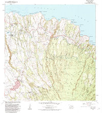
1983 Map of Haiku
USGS Topo · Published 1984About this map
The northern slopes of Haleakalā meet the Pacific coast in this 1980s landscape, where deep erosional features like Maliko Gulch and Kuiaha Gulch define the geography. The map captures the agricultural and residential transition of the upcountry region, centered on the community of Makawao. Significant civic and spiritual sites are documented here, including the St Joseph Sch, Makawao Cem, and the Maui Veterans Cemetery.
Find a feature on this map
101 named features on this map. Tap any name to fly to it.
Don’t see what you’re looking for? This feature index may not catch every label — zoom into the map to look around manually.
Map Details
Editions of this 1983 Haiku Map
2 editions found
Other maps of this area

1954 · Maui
USGS Topo · 1:250,000

1954 · Paia
USGS Topo · 1:24,000

1954 · Puu O Kali
USGS Topo · 1:24,000

1957 · Kilohana
USGS Topo · 1:24,000

1957 · Haiku
USGS Topo · 1:24,000

1957 · Nahiku
USGS Topo · 1:24,000

1957 · Keanae
USGS Topo · 1:24,000

1966 · Maui
USGS Topo · 1:250,000

1974 · Maui
USGS Topo · 1:250,000
1977 · Paia
USGS Topo · 1:24,000