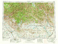
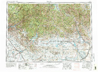
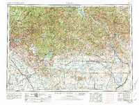
1955 Map of Hailey
USGS Topo · Published 1973About this map
Ketchum and the resort community of Sun Valley serve as the recreational and industrial hubs of this mid-century landscape, where mining operations and high-mountain wilderness meet. The topography is dominated by the massive Boise Mountains and Sawtooth Mountains, while the Snake River Plain to the south supports a growing infrastructure of reservoirs and military installations. Significant mining activity is recorded near the Wood River valley, including the Silver Star-Queens Mine and Triumph Mine, documenting the region's mineral-driven economy before the full shift toward a tourism-based base.
Find a feature on this map
138 named features on this map. Tap any name to fly to it.
Don’t see what you’re looking for? This feature index may not catch every label — zoom into the map to look around manually.
Map Details
Editions of this 1955 Hailey Map
4 editions found

Other maps of this area

1891 · Bear Valley
USGS Topo · 1:125,000

1892 · Mountain Home
USGS Topo · 1:125,000

1892 · Boise
USGS Topo · 1:125,000

1892 · Bisuka
USGS Topo · 1:125,000

1892 · Camas Prairie
USGS Topo · 1:125,000

1893 · Mountain Home
USGS Topo · 1:125,000

1893 · Bear Valley
USGS Topo · 1:125,000

1893 · Camas Prairie
USGS Topo · 1:125,000

1894 · Bisuka
USGS Topo · 1:125,000

1894 · Squaw Creek
USGS Topo · 1:125,000