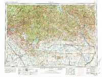
1955 Map of Hailey
USGS Topo · Published 1981About this map
The Camas Prairie stretches across the southern half of this mid-century Idaho survey, defining a high-desert agricultural landscape that transitions into the high peaks of the Sawtooth Mountains and Pioneer Mountains. Along the Wood River, the resort and mining corridor through Hailey, Bellevue, and Ketchum is clearly visible, showing the early infrastructure of Sun Valley. In the southwest, the Mountain Home Air Force Base and its associated Gunnery Range mark the military's footprint on the high plains near Mountain Home. The Union Pacific rail lines serve agricultural outposts like Picabo and Richfield, while a network of reservoirs including Magic Reservoir and Anderson Ranch Reservoir reveals the complex water management system essential for regional survival and power.
Find a feature on this map
91 named features on this map. Tap any name to fly to it.
Don’t see what you’re looking for? This feature index may not catch every label — zoom into the map to look around manually.
Map Details
Editions of this 1955 Hailey Map
4 editions found

Other maps of this area

1891 · Bear Valley
USGS Topo · 1:125,000

1892 · Mountain Home
USGS Topo · 1:125,000

1892 · Boise
USGS Topo · 1:125,000

1892 · Bisuka
USGS Topo · 1:125,000

1892 · Camas Prairie
USGS Topo · 1:125,000

1893 · Mountain Home
USGS Topo · 1:125,000

1893 · Bear Valley
USGS Topo · 1:125,000

1893 · Camas Prairie
USGS Topo · 1:125,000

1894 · Bisuka
USGS Topo · 1:125,000

1894 · Squaw Creek
USGS Topo · 1:125,000