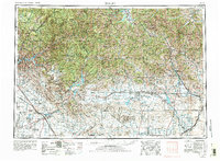
1955 Map of Hailey
USGS Topo · Published 1981About this map
The Sawtooth Mountains and Pioneer Mountains dominate this mid-century landscape, framing the high-altitude development of the Wood River Valley. Following the 1970 revision, the map illustrates the growing prominence of Sun Valley and Ketchum alongside established mining and agricultural centers like Hailey and Bellevue. To the west, the Camas Prairie provides a stark contrast to the surrounding peaks, with small settlements like Hill City and Fairfield linked by Id 68.
Find a feature on this map
177 named features on this map. Tap any name to fly to it.
Don’t see what you’re looking for? This feature index may not catch every label — zoom into the map to look around manually.
Map Details
Editions of this 1955 Hailey Map
4 editions found

Other maps of this area

1891 · Bear Valley
USGS Topo · 1:125,000

1892 · Mountain Home
USGS Topo · 1:125,000

1892 · Boise
USGS Topo · 1:125,000

1892 · Bisuka
USGS Topo · 1:125,000

1892 · Camas Prairie
USGS Topo · 1:125,000

1893 · Mountain Home
USGS Topo · 1:125,000

1893 · Bear Valley
USGS Topo · 1:125,000

1893 · Camas Prairie
USGS Topo · 1:125,000

1894 · Bisuka
USGS Topo · 1:125,000

1894 · Squaw Creek
USGS Topo · 1:125,000